Tag Archives: CrimeView

Using crime analysis solutions to take a ‘Byte’ out of crime

_KOK1002_RTCC+(3)Posted by Crime Tech Solutions 
Law enforcement agencies everywhere are tasked with reducing and investigating crime with fewer and fewer resources at their disposal. “To protect and serve” is the highest responsibilities one can sign up for, particularly in light of recent well-publicized criticisms of police by activists in every city.
That responsibility weighs even heavier in a world with no shortage of criminals and terrorists. There’s never enough money in the budget to adequately deal with all of the issues that face an individual agency on a daily basis. Never enough feet on the street, as they say.
New Tools for Age-Old Problems
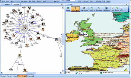
Perhaps that’s why agencies everywhere are moving to fight crime with an evolving 21st century weapon – law enforcement software including investigative case management, link and social network analysis, and, importantly, crime analytics with geospatial and temporal mapping.
analyticscity
Crime analytics and investigation software have proven themselves to be valuable tools in thwarting criminal activity by helping to better define resource allocation, target investigations more accurately, and enhancing public safety,
According to some reports, law enforcement budgets have been reduced by over 80% since the early 2000s. Still, agencies are asked to do more and more, with less and less.
Analytics in Policing

Analytics
Predictive Analytics for Policing

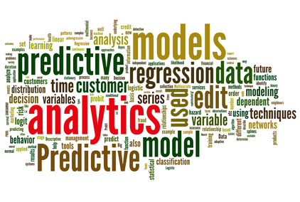
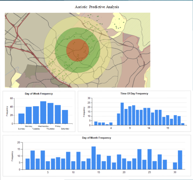
Analytics in law enforcement  play a key role in helping law enforcement agencies better forecast what types of crimes are most likely to occur in a certain area within a certain window of time. While no predictive analytics solution offers the clarity of a crystal ball, they can be effective in affecting crime reduction and public safety.
Predictive analysis, in essence, is taking data from disparate sources, analyzing them and then using the results to anticipate, prevent and respond more effectively to future crime. Those disparate data sources typically include historical crime data from records management systems, calls for service/dispatch information, tip lines, confidential informant information, and specialized criminal intelligence data.
The Five W’s of Predictive Analytics
Within this disparate data lie the 5 W’s of information that can be used by crime analysis software to build predictions. Those key pieces include:

  1. Arrest records – who committed crimes
  2. Geospatial data – where crimes have occurred
  3. Temporal data – when crimes have occurred
  4. Statistical data – what crimes have occurred
  5. Investigation data – why (and how) the crimes occurred

5W
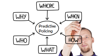
Using the 5 W’s, agencies are able to gain insight and make predictions about likely future criminal behavior. For example, if a certain type of crime (what) tends to occur in ‘this’ area (where) at ‘this’ time (when), and by ‘this’ type of individual (who) for ‘this’ reason (why)… it would be wise to deploy resources in that area at that time in order to prevent the incidents from ever occurring. This, of course, is a dramatic over-simplification of the types of analytics that make up predictive policing, but illustrates the general concept well.
Although criminals will always try to be one step ahead of the law, agencies deploying predictive analytics are able to maximize the effectiveness of its staff and other resources, increasing public safety, and keeping bad guys off the street.
More about Crime Tech Solutionsblack version
Crime Tech Solutions is an Austin, TX based provider of crime and fraud analytics software for commercial and law enforcement groups. Our offerings include sophisticated Case Closed™ investigative case management and major case management, GangBuster™ gang intelligence software, powerful link analysis software, evidence management, mobile applications for law enforcement, comprehensive crime analytics with mapping and temporal reporting, and 28 CFR Part 23 compliant criminal intelligence database management systems.

Data continues to influence policing

Great article by Megan Favignano at New Press Now. Original article at http://www.newspressnow.com/news/local_news/data-continues-to-influence-policing/article_ef968ba2-389c-5289-b341-a9818ae231d7.html
A copy of the article follows:
5WA recent report questions how some police departments are using data to forecast future crimes.
The report examined how departments are utilizing predictive policing, a computer software that uses data to forecast where crime may happen, who may commit it and who could be potential victims.

Logan Koepke, an analyst who coauthored the report, said the handful of departments that use the software don’t appear to give patrol officers much guidance on what to do with the information provided.
“One problem we’ve seen is there is not a lot of direction from police departments or from vendors about what officers in the field should do once they look at a prediction,” Koepke said.
Upturn, an analysis organization out of Washington, D.C., that works with a variety of groups, published the report “Stuck in a Pattern” last month. “Predictive policing,” the report states, is a marketing term popularized by vendors who sell the software.
The group’s research showed areas that use the software often don’t engage the public in discussion about predictive policing and questioned whether or not departments who use it are measuring the impact the data-driven tool has on policing and crime rates.
AnalyticsHow police departments nationwide utilize crime statistics and the software available to patrol officers monitoring incidents has evolved a lot in the past couple decades, Sgt. Tracy Barton with the St. Joseph Police Department said. Barton started as a patrol officer 20 years ago. He said having software like police have today would have been useful.
“I was in District 7, which is the Midtown area. It would have been really cool to know where crime is occurring in District 7 and that I could look that up on a computer and have it at my fingertips where I could see it on an up-to-date basis,” Barton said.
In the past, crime analysts used physical maps and mathematical algorithms to do what software does instantly today. Barton, the St. Joseph Police Department’s crime analyst, uses software that takes into account crimes reported to police to show crime hot spots in the city. A map of those hot spots is available online. Officers, he said, have access to a more in-depth version of that hot spots map, which includes extra details about the area and the crimes occurring.
The hot spots approach St. Joseph police use is most helpful in preventing crime when a series of crimes occur or when there is a crime pattern in a given area, he said. St. Joseph’s small size, Barton added, poses an extra challenge.
Crime analytics Mapping Predicitive Policing
The St. Joseph Police Department has had its current software for just a few years. It doesn’t fit the definition of the predictive policing software Upturn outlines in the recent report. The software used locally depends on crime reports police receive. Predictive policing also looks at what types of business are located in an area, if repeat offenders live nearby and other information to predict where crimes may occur. Typically, according to the recent report, predictive policing takes one of two approaches, focusing either on place-based data or person-based data to make predictions.
Kevin Bryant, sociology and criminology professor at Benedictine College, said when people hear predictive policing described, they often think of the movie “Minority Report.” The software, he said, is nothing like in the movies.
“Predictive policing now has kind of morphed into better proactive methods that are based on prediction to some extent in forecasting risk,” Bryant said of how data-driven policing has changed over time. “But what we’ve learned through evaluation studies is that it’s really more important what the police do when they’re in a crime hot spot.”
Ba10ryant worked with the Shawnee, Kansas, Police Department on research that looked at what he calls “smart policing.” In his research and in other work he has read, Bryant said it’s important for police to have a high visibility in crime hot spots, for officers to make connections with the public and for them to avoid staying in crime hot spots for extended periods of time.
When police are in a hot spot for too long, public surveys show area residents feel like they are being picked on rather than protected, he said. Predictive policing takes into account businesses in a given area. Bryant said some types of facilities are at a higher risk of victimization and others can attract crime to an area.
“Knowing where bars, taverns, restaurants, gas stations, convenience stores are, we can actually use their locations as a means of forecasting where crime might emerge at a later date,” Bryant said. “Part of predictive policing is predicting who the risky offenders are and that can be controversial.”
Upturn’s report also explored an ongoing debate among criminologists on the impact of using crime reports when determining patrol.
“Criminologists have long emphasized that crime reports and other statistics gathered by the police are not an accurate record of the crime that happens in a community,” the report states.
Police statistics, Koepke said, reflect officer enforcement efforts, not just crime.
 black version

Crime Hot Spots and Risk Terrain Modeling

abmpegasus-intelligence-led-policing
A typical ‘hot spot’ in crime analytics

By Tyler Wood, Operations Manager at Crime Tech Solutions.
One of the many functions crime analysis performs is the identification of “hot spots”, or geographical areas that seem to be hubs for criminal activity. Identifying these hot spots through best practices in geospatial crime mapping allows law enforcement to focus their efforts in areas that need them most. The trouble that law enforcement and crime analysts have encountered is displacement – the fact that once a hot spot is “cleared”, crime seems to pop up again in a different location. The good news is that the displacement is never 100%, so policing hot spots is important – it’s just not a magic bullet.
To solve this problem, a team at Rutgers University’s School of Criminal Justice set out to develop new methodologies that would result in peaceful outcomes that are built to last instead of merely temporary.
The difference between the old approach and the new approach is stark. Where police and analysts used to focus solely on geographical concentration of crimes, Risk Terrain Modeling examines the factors that contribute to such dense concentrations to begin with. Rutgers team have identified several characteristics of any given geographical location which may attract or generate crime. Their technology takes these characteristics, which include socioeconomic data, physical layout, types of local businesses, etc… and uses them to calculate the likelihood crime occurring in the area. This allows law enforcement to be proactive in the prevention of crime in these areas.
CrimeMapLite
Advanced crime analytics show statistically significant risk factors.

The technique seems to be highly effective. After a trial run in New Haven, CT, police were able to identify sixteen “statistically significant risk factors that underlie violent crime occurrences.” A high percentage of violent crime in New Haven during the test period occurred in locations already identified by the concept of risk terrain modeling. Though the technology is still new, it is clearly showing impressive results already.
Shutting down hot spots is important policing, and risk terrain modeling technology allows analysts and law enforcement officers to be even more proactive in their prevention of crime.
The author, Tyler Wood, is head of operations at Austin, TX based Crime Tech Solutions – an innovator in crime analytics and law enforcement crime-fighting software. The clear price/performance leader for crime fighting software, the company’s offerings include sophisticated Case Closed™ investigative case management and major case management, GangBuster™ gang intelligence software, powerful link analysis software, evidence management, mobile applications for law enforcement, comprehensive crime analytics with mapping and predictive policing, and 28 CFR Part 23 compliant criminal intelligence database management systems.)

Crime Tech Solutions Acquires Case Closed Software

June 1, 2016 (Austin, TX)   Crime Tech Solutions, LLC, a leading provider of analytics and investigation software for law enforcement and commercial markets, today announced that it has acquired Cleveland, TN based Case Closed Software in a cash transaction. The terms of the deal were not released, but according to Crime Tech Solutions’ founder and president Douglas Wood, the acquisition brings together two dynamic and fast-growing software companies with an unparalleled complement of technologies.
For Crime Tech Solutions, the opportunity to add Case Closed Software into the fold was too good to pass up” said Mr. Wood. “We think that the technology offered by Case Closed helps to further differentiate us in the market as the price performance leader for this type of investigative solution.PNG
Crime Tech Solutions, based in the city of Leander, TX, delivers advanced analytics and investigation software to commercial investigators and law enforcement agencies across the globe. Their solution suite includes criminal intelligence software, sophisticated crime analytics with geospatial mapping, and powerful link analysis and visualization software. The company says that the addition of Case Closed Software expands those offerings even further.
Case Closed Software develops and markets investigative case management software specifically designed for law enforcement agencies. The suite is built around four primary software products including best-in-class investigative case management software, property and evidence tracking, a gang database tool, and an integrated link analysis and data visualization tool. The company also plans to release the solution as Case Closed Cloud for cloud-based access.
Case Closed couldn’t be happier than to be joining Crime Tech Solutions,” said Keith Weigand, the company’s founder. “The blending of our technologies creates a suite that will add tremendous value to our mutual customers, and will be hard for others to duplicate.
According to both Mr. Weigand and Mr. Wood, the name Case Closed will continue on as the product brand, given its widespread popularity and loyal customer base. Crime Tech Solutions is expected to retain all Case Closed employees, with Mr. Weigand joining as the company’s chief technical officer.
Crime Tech Solutions says it expects continued growth via ongoing software sales and strategic acquisitions.
About Crime Tech Solutions
(NOTE: Crime Tech Solutions is an Austin, TX based provider of crime and fraud analytics software for commercial and law enforcement groups. Our offerings include sophisticated Case Closed™ investigative case management and major case management, GangBuster™ gang intelligence software, powerful link analysis software, evidence management, mobile applications for law enforcement, comprehensive crime analytics with mapping and predictive policing, and 28 CFR Part 23 compliant criminal intelligence database management systems.)

CrimeView and TriTech – Concerned? Maybe you should be.

Posted by Tyler Wood, Operations Manager at Crime Tech Solutions
keep-calm-and-investigate-on-7In the release of a not so well-kept industry secret, Trimble (NASDAQ: TRMB) finally announced this week (February 29, 2016)  that it has sold The Omega Group assets to TriTech Software Systems, a leading provider of public safety software. The Omega Group is a large provider of crime mapping software, known for its popular CrimeView™ desktop software and the www.crimemapping.com™ website which allows agencies to present crime statistics to the public in a heat map format.
According to the press release, TriTech intends to grow the acquired business as part of its public safety portfolio. Financial terms of the sale were not disclosed.
So, TriTech continues its acquisition strategy… having already acquired Visionair, Tiburon and Information Management Corp (IMC) over the past decade. Visionair and Tiburon were providers of Records Management Systems (RMS) and Computer Aided Dispatch (CAD) systems for law enforcement.
The previous acquisitions made a great deal of sense for TriTech, as well as the companies being acquired. Most importantly, those acquisitions had no negative affect on the most important group of all – the users and customer base. The acquisition of The Omega Group and CrimeView, however, not so much.
The Omega Group has long been close partners with ESRI®, by far and away the leading developer of GIS mapping technology anywhere. That relationship with ESRI had helped Omega grow into the market force it has become. Of equal importance to that success, however, was the positioning that Omega Group – and their suite of crime map products – were data agnostic and would work with a wide variety of RMS and CAD systems.
Under TriTech’s ownership, however, I don’t see how that ‘impartiality’ continues. TriTech’s previous acquisitions have quickly blended into part of an overall powerful suite of tools – perhaps second to none in the industry – that they market so successfully. Why would we not expect CrimeView et al to follow the same path?
If you’re a current TriTech customer, the acquisition probably has little or no affect on you. Perhaps there’s even an upside as they work to integrate the crime mapping offerings into their other solutions further.
If you’re NOT a TriTech customer, however… well, this is not so good for you. It’s not unreasonable to expect that the company will continue to support third party RMS and CAD implementations for some period of time, but I expect the crime map products to grow in functionality specifically in line with TriTech’s own product set.
Here are our concerns:

  1. As a user of Omega Group products do you have reason to be concerned that support and development for you will slowly phase out? I’d think so, as TriTech is in the business of selling RMS and CAD solutions.
  2. If you’re ESRI, can you continue your cozy relationship with a company and product set now owned by a large entity who, by definition, has no interest in growing the non-TriTech base?
  3. If you’re a competitor to TriTech, can you continue to work with someone who would much prefer to take away your install base than partner with you on the crime map side?

There are low-end, inexpensive competitors to CrimeView but frankly they don’t compare to the functionality and are designed for the very smallest of agencies. CrimeMap from Crime Tech Solutions, on the other hand, is also a partner with ESRI and has a vested interest in remaining agnostic as to the RMS or CAD systems in place. It’s how the company does business.
CrimeMap is a top-tier desktop solution that includes all of the functionality you’d expect, PLUS includes advanced crime analytics, integration with our powerful criminal intelligence database system, and an incredibly useful connectivity to our price/performance leading link analysis solution.
One has to admire TriTech for their continued growth and execution of a solid acquisition strategy. In this acquisition of Omega Group, however, they have put ESRI, end-users, and competitive vendors in an awkward spot.
(NOTE: Crime Tech Solutions is an Austin, TX based provider of crime and fraud analytics software for commercial and law enforcement groups. We proudly support the Association of Certified Fraud Examiners (ACFE), International Association of Chiefs of Police (IACP), Association of Law Enforcement Intelligence Units (LEIU) and International Association of Crime Analysts (IACA). Our offerings include sophisticated link analysis software, comprehensive crime mapping and predictive policing, and criminal intelligence database management systems.)
 

Policing in my hometown (Winnipeg) gets smart

Posted by Douglas Wood, Crime Tech Solutions
As a native Winnipeg boy, this article in the Winnipeg Sun caught my attention…
1297227913993_ORIGINALThe government of Manitoba, Canada won’t be making good on its 2011 election pledge to put an extra 50 cops on the streets to combat crime and keep Winnipeg neighborhoods safe.

But it’s not because the province is unwilling.  It’s because the city of Winnipeg doesn’t want more cops.
That may seem odd for a city with the highest violent crime rate in the country. But as policing resources shift away from boots on the ground to more crime-analysis based law enforcement, it’s not more sworn officers the Winnipeg Police Service wants, it’s more resources for so-called smart policing strategies.
“The interest of Winnipeg Police Service is not in officers so much as in crime analysis and smart policing and they have a different approach,” Justice Minister Gord Mackintosh told a legislative committee on Monday. “They do not have an interest in just adding more.” The New Democratic Party promised voters during the last provincial election that it would fund 50 additional officers if re-elected. But four years later, the province has only funded 23 more officers. And there won’t be any new funding for more officers, said Mackintosh.
“The commitment was 50 more officers and we’re now at the equivalent of 23,” said Mackintosh. “The city has requested that the election commitment not be implemented as enunciated during the campaign.” It’s a major shift from years past when provincial parties regularly pledged to put more cops on the street by directly funding the Winnipeg Police Service. The former government was the first to make the promise in 1995 when it promised 40 more police officers for Winnipeg.
The province now directly pays for the salaries and benefits of 172 Winnipeg officers, according to a 2014 report.
And while that funding is expected to continue, the city doesn’t want more money for cops. They want it to help fund other aspects of policing, including more preventative measures, said Mackintosh.
“This is a different approach that is gaining momentum not just here in Winnipeg but in other jurisdictions across the continent,” said Mackintosh. “It’s really about hot spot policing now, it’s about data analysis, looking at the types of offences where they occur, the time of day.” Winnipeg police board chairman Coun. Scott Gillingham confirmed the city isn’t looking for more funding to expand the police complement further. He says police are looking to hire more crime analysts, which can be civilians, not more cops.
“The opportunity and the need would be to focus on preventative measures through things like the smart policing initiative (and) intelligence-led policing,” said Gillingham.
What police also need, though, is more help with the additional workload they’ve taken on as they deal increasingly with mental health patients, Child and Family Services cases and soaring domestic abuse calls.
Police may be moving towards a more data-based approach to law enforcement, but they’ve also become a service of last resort for a growing number of tough social service cases, including tracking down chronic runaway wards of the state on a regular basis.
Which means they’re going to need a lot more support from provincial agencies to pick up some of that slack.
Winnipeg police may not need more boots on the ground. After all, Winnipeg does have the most cops per capita of any Canadian city, and has for some time.
But the province is going to have to figure out how to better manage the social service cases that are landing increasingly at the doorstep of police.

Crime Mapping. More than Law Enforcement?

Posted by Crime Tech Solutions
Geographic information systems aren’t exactly new. Drugstore chain Walgreens has used the technology for close to 15 years for market planning.
More recently, however, the company has endowed that visual information with location-specific data—and published far more broadly, so that store managers and its corporate real estate team can use it for planning.
The system, called WalMap, can be used to visualize local community trends. A spike in flu medication prescriptions could help store managers decide earlier to order more vaccine, preventing shortages. Walgreens sales executives can reference trends in supplier conversations. Plus, the interactive maps can be used by the corporate planning team to determine the best place for a new store, based on community demographics, competitor information, and sales trend information. They can even be viewed on an iPad.
“Ten years, our teams had to print out a map and take it with them. Now they can bring their mobile device, and have access to updated sales, demographics and other targeted information,” said Jillian Elder, director of enterprise location intelligence for Walgreens.

Occasionally the maps serve a higher purpose. Managers in Texas in September were able to help local authorities predict the next targets for a local crime spree. “With some of our visualizations, we were able to put a stop to this,” Elder said.

The resource houses millions of maps available to companies that want to overlay proprietary data with the most up-to-data public information about specific locations. There are literally millions of maps published there. Most internal teams have access to basic information; Elder’s team created a special addition specifically for Walgreens’ real estate, strategy, and mergers and acquisition teams.
As of the latest FAQ information on its corporate web site, Walgreens generated more than $76 billion in sales last year across more than 8,300 locations across the United States and Puerto Rico.

What is Geospatial Crime Mapping?

Geospatial4Posted by Crime Tech Solutions with information gathered from Wikipedia.
Here’s a fact: Any understanding of where and why crimes occur can help prevent future crimes.
Mapping crime can help law enforcement protect citizens more effectively. Simple maps that display the locations where crimes or concentrations of crimes have occurred can be used to help direct patrols to places they are most needed. Policymakers can use more complex maps to observe trends in criminal activity; such maps can prove invaluable in solving criminal cases. For example, detectives can use maps to better understand the hunting patterns of serial criminals and to hypothesize where these offenders might live.
Products like CrimeMap Pro™ from Crime Tech Solutions are used by analysts in law enforcement agencies to map, visualize, and analyze crime incident patterns. It is a key component of crime analysis and the CompStat policing strategy. Mapping crime, using Geographic Information Systems (GIS), allows crime analysts to identify crime hot spots, along with other trends and patterns.CrimeMapLite

Using GIS, crime analysts can overlay other datasets such as census demographics, locations of pawn shops, schools, etc., to better understand the underlying causes of crime and help law enforcement administrators to devise strategies to deal with the problem. GIS is also useful for law enforcement operations, such as allocating police officers and dispatching to emergencies.

Crime analysts use crime mapping and analysis to help law enforcement management (e.g. the police chief) to make better decisions, target resources, and formulate strategies, as well as for tactical analysis (e.g. crime forecasting, geographic profiling). New York City does this through the CompStat approach, though that way of thinking deals more with the short term. There are other, related approaches with terms including Information-led policing, Intelligence-led policing, Problem-oriented policing, and Community policing. In some law enforcement agencies, crime analysts work in civilian positions, while in other agencies, crime analysts are sworn officers.
From a research and policy perspective, crime mapping is used to understand patterns of incarceration and recidivism, help target resources and programs, evaluate crime prevention or crime reduction programs (e.g. Project Safe Neighborhoods, Weed & Seed and as proposed in Fixing Broken Windows), and further understanding of causes of crime.
The boom of internet technologies, particularly web-based geographic information system (GIS) technologies, is opening new opportunities for use of crime mapping to support crime prevention. Research indicates that the functions provided in web-based crime mapping are less than in most traditional crime mapping software. In conclusion, existing works of web-based crime mapping focus on supporting community policing rather than analytical functions such as pattern analysis and prediction.