Posted by Tyler Wood, Operations Manager at Crime Tech Solutions.

Crime mapping technology is a powerful and valuable tool for law enforcement. The ability to represent crime statistics visually – in a meaningful way – is helping police forces across America to analyze, understand, predict, and even prevent crime. It is, however, important to use caution when using such powerful tools, in order to prevent incorrect analyses of crime statistics that may hinder, rather than help, an investigation.
Specifically, there are a few key mistakes which should be avoided when utilizing this sort of predictive technology.
- Obviously, crime reporting should be thorough and detailed. Crime mapping technology takes a great many factors into consideration when developing a visual analysis of a certain area. The more detailed the input is, the more accurate the predictions and visualizations will be.
- Not every crime occurs at a specific street address. Certain crimes, like personal theft, may not be noticed until hours or even days after they occur, making it difficult to define an exact location at which the crime was committed. Analysts should take care to visualize each location in which it could have occurred.
- When developing a crime map of an area, analysts should take care to split the data between daytime and nighttime hours, as many areas have significantly different rates of crime depending on the time of day. If time is not taken into consideration, data can become skewed and law enforcement can develop a warped picture of the area.
- It is also important for analysts to consider other factors that affect crime reporting within a specific area. For example, petty crimes may be reported less often in lower-income neighborhoods. Care should be taken to consider the demographics and socioeconomic standings of the area being mapped in order to provide more context which can help analysts to more accurately predict and prevent crime.
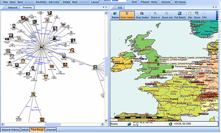 Combining, where possible, the functionality of link analysis into the crime mapping process brings powerful additional functionality. This ability to link, not only statistical, but entity-specific data is a potential game changer.
The role of crime mapping in the world of law enforcement is gaining popularity. Unfortunately, for many police departments, the cost of a full suite of software from category leader, ESRI is prohibitive. Still, there are options available… notably, CrimeMap Pro from Crime Tech Solutions.
___
(NOTE: Crime Tech Solutions is an Austin, TX based provider of crime and fraud analytics software for commercial and law enforcement groups. We proudly support the Association of Certified Fraud Examiners (ACFE), International Association of Chiefs of Police (IACP), Association of Law Enforcement Intelligence Units (LEIU) and International Association of Crime Analysts (IACA). Our offerings include sophisticated link analysis software, comprehensive crime mapping and predictive policing, and criminal intelligence database management systems.)